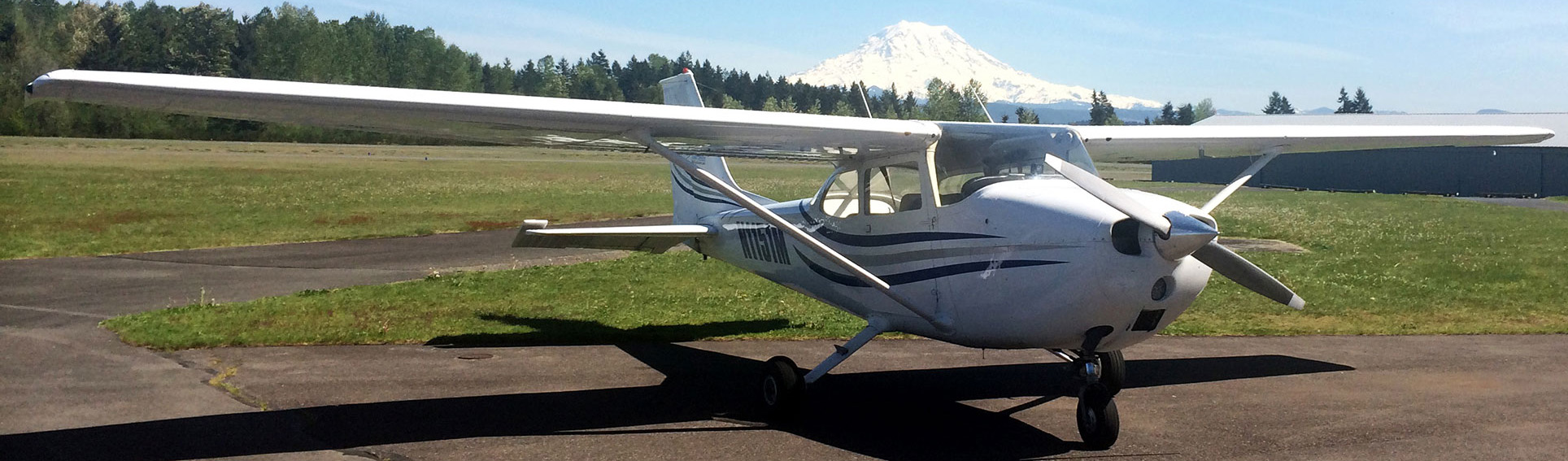
Wow! What an amazing day I had today flying! I’ve been waiting to do my long Cross Country flight for a couple of weeks now due to weather. Today the weather gods smiled upon me and I got an amazing amount of flying in. The plan for the day was to take off out of Puyallup (KPLU) Thun Field, cross over McChord AFB, hang a left at Anderson Island, overfly Olympia (KOLM), overfly Centralia/Chehalis (KCLS), hang a right over Kelso (KKLS) and follow the Columbia River to Astoria, Oregon (KAST). After landing at Astoria, I would stretch my legs, then hop back in the plane for a trip to Hoquiam, land there, stretch my legs and finally head back to Pierce County, Thun Field skirting around the Rainier Military Operations Area (MOA) to the South, overflying Eatonville airport on the way. My flight was scheduled for 12:00PM and I had … Read More
First Solo Cross Country Flight!
Today marked another milestone in my journey to become a private pilot. Today I did my first solo cross country flight. No I didn’t fly from Washington to Florida. A cross country flight is defined as a flight that is more than 50 nautical miles from your home airport. This is a pretty big deal. This is where you really put all your skills to the test. Can you successfully navigate from your home airport to another airport dozens of miles away using all the skills you’ve learned so far? Of course you have to know how to takeoff, fly and land the plane. It seems as though that’s all you’ve been practicing for weeks. But can you use pilotage and dead reckoning? Can you navigate the dozens of frequencies on the radio you’ll need to get from point A to point B? How about using the E6-B flight computer … Read More
Bravo…Class Bravo…
OK today I’m simply giddy with excitement! I got to do my third cross country flight, my longest time in the plane yet, 2.3 hours. I haven’t spent the time to total up my log book yet, but I’ve got to be closing in on 20ish hours of flight time. Today, our route was from KPLU (Thun Field) to 0S9 (Jefferson County Airport) up on the Peninsula. The way I planned it was like this: Take off out of KPLU and head pretty much due west, crossing over McChord AFB (KTCM). Which means I’d have to contact their tower and ask permission to cross over. Once we were past McChord, and over Harstine Island, I’d turn us just a little west of North and follow one of the designated Airways (Think Highway in the sky) using the Olympia VOR pretty much all the way up to Jefferson County Airport. Passing … Read More
My First Cross Country Flight
Today (Sunday) I hit another milestone in my flight training, my first cross country flight! As I’ve mentioned before a cross country flight is a flight more than 50 nautical miles from your home airport. The plan today was to fly from KPLU (Thun Field) to KHQM (Hoquiam). My flight lesson started at 9:00 AM, and I booked 4 hours of time. I got up at 7AM and started plotting my course on the Sectional Chart and filling out my flight plan. I quickly realized I hadn’t allowed myself enough time to plan this flight! It’s crazy that a 2 hour flight, takes that long to plan. I’m sure as I get better at it I will be faster, but today there definitely was a steep learning curve. I called Lockheed Martin Flight Services for a standard weather briefing. Told them we’d be cruising from KPLU to KHQM at … Read More
A Little Simulator Time Today…
One of the plusses of flying at Safety In Motion Flight Center is that they have a Redbird FMX full motion Flight Simulator. Occasionally I think of it as a drawback when in reality it’s a pretty amazing training tool. Today Meg and I were supposed to fly to KTIW (Tacoma Narrows) where, winds permitting, I was actually going to get to land today. Unfortunately it wasn’t the winds that stopped us. We occasionally have a marine layer that settles in the Puget Sound region and doesn’t burn off until noon or so. That was the case this morning. When I woke up it was pretty overcast and I called Lockheed Martin Flight Services for a Standard Weather briefing already knowing that the cloud layer was too low. The cloud layer was reported at 1,900 feet for McChord and 1,800 feet at KTIW. As the plan was to fly from … Read More